 Excavating and
  Rough and Fine
  Paving, Milling
 GNSS & Network
 Total Station Solutions
 Mass Data and Volume Collection
 Field Controllers
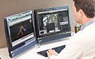 Field and Office Software Solutions
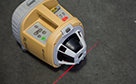 Laser Solutions
 Levels and Theodolites
 Enterprise Services and Subscriptions
  Support and Warranty
Topcon announces increased 3D scanning integration with Autodesk solutions
News Index
Topcon announces increased 3D scanning integration with Autodesk solutions
June 2, 2015
LIVERMORE, Calif., USA/ CAPELLE A/D IJSSEL, the Netherlands – 2nd June 2015 – As a result of the strategic business relationship with Autodesk, Topcon Positioning Group announces improved workflow compatibility for the GLS-2000 3D laser scanner and ScanMaster software with Autodesk solutions via the latest version of Autodesk ReCap.
The GLS-2000 pairs with Topcon ScanMaster software to collect, process, edit and deliver 3D point cloud data from a laser scanner for a variety of applications. Autodesk ReCap allows users to perform tasks such as scan conversion, editing, and viewing point cloud data — and provides integration with Autodesk’s broader portfolio of design software.
Autodesk ReCap and ReCap 360 have the new capability to read the Topcon CL3 format as a scan file in addition to a standard point cloud. The scan file allows for the use of individual scan positions for additional options in registration workflows.
“File conversion is no longer necessary — exporting can be done straight out of scan position. Users ultimately get a more streamlined workflow, more data detail and increased access to the point cloud,” said Ray Kerwin, director of global surveying products. “With individual scan positions it is possible to generate ‘RealViews’ that offer a web viewing output.”
The integration is available for versions including Autodesk ReCap, ReCap 360 and ReCap 360 Ultimate software.
Please click here for full Press Release Kit including hi-res images ~ 9.2mb
Autodesk, the Autodesk logo, ReCap and ReCap 360 are trademarks or registered trademarks of Autodesk, Inc. and/or its subsidiaries and/or affiliates, in the USA and/or other countries. All other brand names, product names, or trademarks belong to their respective holders.
MORE STORIES

Topcon and Kuhn agree on sales partnership
Topcon Europe Positioning and the Kuhn Group have agreed on a sales partnership, designed to considerably strengthen the Topcon distribution network in Southern Germany, Austria, Czech Republic... Learn More

Topcon introduces rotary-wing UAS for Europe
Topcon Positioning Group announces the addition of a rotary-wing unmanned aerial system (UAS) to its mass data collection solutions line for the European marketplace. The Falcon 8 - powered by... Learn More

Topcon announces partnership with Ascending Technologies for UAS worldwide distribution
Topcon Positioning Group announces a worldwide distribution partnership with Unmanned Aerial System (UAS) provider Ascending Technologies. The agreement gives Topcon exclusivity for the global... Learn More